The introduction of Galileo signal in solutions that rely on positioning is proving great benefits and new opportunities for the industry, thanks to its enhanced performance and increased accuracy. Rokubun experience is a good example of how Galileo can bring significant benefits to precision agriculture by adding a constellation on top of the traditional GPS and GLONASS, increasing the number of satellites in view, thus allowing accurate drone photogrammetry operations in areas with poor satellite coverage, such as closed valleys or fields that are on the edges of forests.
REAPING THE FRUITS OF EUROPE’S GNSS
Rokubun, a company set in Barcelona, focuses on the democratization of precision navigation for the mass-market, offering positioning solutions targeted to location-based devices and services, and, in particular, to Unmanned Aerial Vehicles (UAV), Vehicle-to-everything (V2X) technologies (Connected Cars), wide area logistics, and precision farming. They are among the founding members of the GSA GNSS raw measurement taskforce, a group of prominent experts in charge of learning exchange and knowledge dissemination on Android raw measurements and its use for precise navigation.
During the last year, the company has been involved in several projects related to the development of precise positioning algorithms for smartphones and autonomous driving. As a leading manufacturer and algorithm developer, Rokubun is leveraging the benefits of the Galileo system, such as how the more efficient modulations of Galileo signals mitigate the multipath, integrating it into their solutions. Thanks to this, autopilots designed to drive tractors can operate in difficult environments.
MULTIPLE POSSIBILITIES FOR AGRICULTURE APPLICATIONS
According to Isaac Hoyas Ester, navigation engineer at Rokubun “The multi-constellation scenario, together with the benefits of introducing the processing of Galileo signals, have contributed to the development of several positioning solutions such as Argonaut + JASON, which provides a real-time and post-processing navigation solution for drones.”
Argonaut GNSS receiver provides the positioning solution to the navigation computer (e.g. drone autopilot) in real time and in parallel it stores GNSS raw data along with camera shots to be post-processed in Rokubun’s service.
The raw data collected by Argonaut GNSS receiver (or by any other GNSS receiver) can be post-processed within Rokubun’s cloud service, JASON. In this way the end user can obtain accurate navigation information without the need of expensive software nor field-deployed radio links.
JASON enables accurate drone photogrammetry without the need of ground control points, saving customers time and money. In fact, this solution does not only apply to drones but also to any other precision agriculture applications, resulting in a good solution for tractors and plant health monitoring.
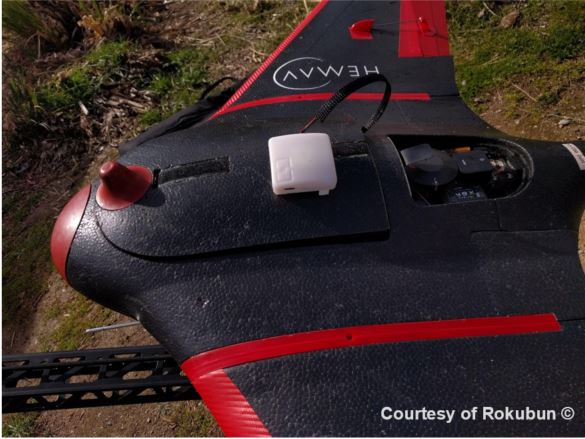 [Figure 1: Argonaut solution by Rokubun mounted on a drone]
An example of this application is implemented by MDrone for the assistance of a tractor trajectory as it is driving parallel passes in a vineyard. A camera mounted perpendicularly to the trajectory shoots a picture each time it is near a grape plant. Thanks to the accurate geo-tagged position of the picture provided by JASON the farmers can see and analyse the plants from both sides and monitor their health.
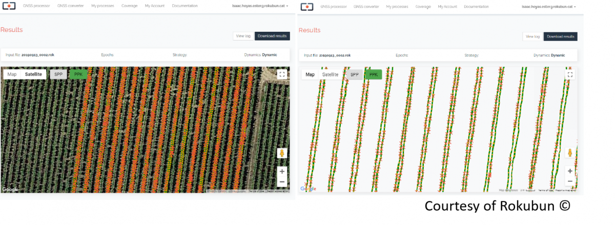 [Figure 2: Geo-tagged picture captures from a tractor driving parallel passes in a vineyard by MDrone ]
GALILEO AS PART OF AN INTEGRATED SOLUTION
Rokubun and MDrone experiences demonstrate how Galileo contributes to the development of integrated solutions, combining several cutting-edge technologies with satellite positioning techniques and navigation solutions.
We would like to thank Rokubun team for their availability and cooperation in preparing this story.
Media note: This feature can be republished without charge provided the European GNSS Agency (GSA) is acknowledged as the source at the top or the bottom of the story. You must request permission before you use any of the photographs on the site. If you republish, we would be grateful if you could link back to the GSA website (http://www.gsa.europa.eu).