The ARGONAUT project is making low-cost, high-precision GNSS receivers a viable option for all drone operators.
Perhaps nobody understands the need for 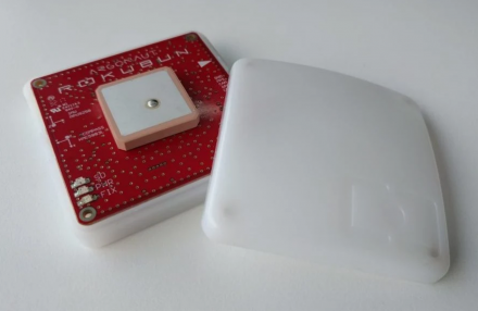 post-process geolocation accuracy better than drone operators. But being able to satisfy this need is a different story. This is because most of the accurate systems currently on the market capable of offering results within decimetres – such as GNSS receivers – cost thousands of dollars. As this figure is often well-beyond what many drone operators can afford, most have had to settle for less accuracy.
Luckily, things are beginning to change. “We are witnessing exciting times, as low-cost, high-precision GNSS receivers are coming onto the market and challenging the dominance of the older, expensive and overly complex models,” says Xavier Banqué-Casanovas, CEO of Rokubun, the company behind the development of the ARGONAUT project.
ARGONAUT is a fully integrated GNSS receiver designed to meet the need for high-precision geo-location data. It achieves better than 30 cm horizontal accuracy when post-processing is done using JASON Positioning as a Service (PaaS), an adaptable cloud post-processing service developed and regularly updated by Rokubun’s GNSS team.
For high-precision solutions
According to Xavier, the development of ARGONAUT was driven by the need for affordable high-precision geo-location solutions. The result is an innovative combination of GNSS receivers and PaaS perfectly suited to meet the UAV community’s needs with the market’s best cost-accuracy ratio. “Regardless of the task being performed, an accurate GNSS receiver is a must for all UAV models,” says Xavier. “An unmanned system without a proper geolocation solution simply cannot be employed for drone applications for which the final outcome needs to be precisely orthorectified.”
ARGONAUT is equipped to track all global navigation systems, including Galileo, along with such regional systems as EGNOS. According to Xavier, ARGONAUT’s multi-constellation capability increases exposure to more satellites in view, thus greatly enhancing its robustness in reduced sky visibility conditions, such as urban canyons. “For us, the use of Galileo basically translates into being able to provide a better service in harsh environments” he explains.
Using the system
To use the system, all one has to do is mount the ARGONAUT multi-constellation receiver onto the drone. Since it is light and small, it works on all UAV models and serves both as the main GNSS receiver and the synchronising GNSS payload. During flight, the receiver tracks its position, logging it onto the embedded SD card. When you’ve gathered enough data, simply land the drone, remove the SD card from the receiver and upload its data to your computer.
Before post-processing, the measured position typically differs from the actual one, with an error of around two meters. Although this level of accuracy is suitable for navigation, it isn’t enough for high-precision tasks. So, to enhance the geo-location, simply go to the Rokubun JASON cloud service and drag and drop the raw data file to process it. From here, the PaaS uses advanced processing techniques to bring down the level of error to less than half a meter. You then receive instant, ready-to-use accurate positioning and geo-tagged events (such as camera shots).
Most recently, the company has updated the device’s firmware so it is plug-and-play compatible with Pixhawk2, the most popular professional drone controller. But perhaps the best news is that this level of accuracy is now available for just $350.00 – up to 10 times cheaper than other professional navigation systems. “Used alone or together with our Positioning-as-a-service, ARGONAUT stands out from the competition for combining accuracy and affordability into one state-of-the-art, easy to use solution,” concludes Xavier.
Media note: This feature can be republished without charge provided the European GNSS Agency (GSA) is acknowledged as the source at the top or the bottom of the story. You must request permission before you use any of the photographs on the site. If you republish, we would be grateful if you could link back to the GSA website (http://www.gsa.europa.eu).