OrbFIX, aboard EMISAR CubeSat, validates the use of the operational Galileo High Accuracy Service (HAS) in Low Earth Orbit, paving the way for more autonomous and precise space missions.
Accurate positioning is becoming increasingly critical for Low Earth Orbit (LEO) missions, enabling applications such as autonomous spacecraft operations, formation flying, collision avoidance, and future in-orbit servicing activities.
Since the declaration of the Galileo High-Accuracy Service (HAS) Initial Service in January 2023, users worldwide have benefited from free global Precise Point Positioning (PPP) corrections delivered via both the Galileo E6-B signal and internet distribution channels. Under nominal conditions, these corrections enable decimetre-level positioning accuracy.
While Galileo HAS was originally developed for terrestrial applications, extending its benefits to user operation within the Space Service Volume (SSV) represented a significant technological challenge.
To address this, the company Romanian In Space Engineering (RISE) developed OrbFIX, a compact, radiation-tolerant GNSS receiver specifically designed for small satellite missions. Fully compatible with Galileo HAS, OrbFIX combines multi-constellation and multi-frequency GNSS processing with a low-power, space-qualified architecture optimised for LEO platforms.

OrbFix HAS-capable receiver
OrbFIX was integrated aboard EMISAR, a 1U CubeSat launched on 30 April 2026 on the SpaceX’s Transporter-16 mission into a 520 km Sun-Synchronous Orbit (SSO). Following launch, OrbFIX became the first Galileo HAS-capable receiver to process operational Galileo HAS corrections in orbit, marking a major milestone for both the European GNSS ecosystem and the New Space sector.
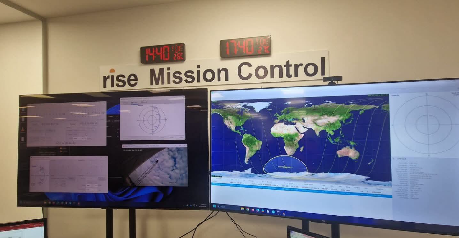
RISE Mission Control Centre
Results
The in-orbit demonstration successfully validated the reception and use of Galileo HAS corrections under real operational conditions.
During a representative pass over Antarctica on 7 October 2026, OrbFIX was powered on and delivered 38 successful single point position (SPP) solutions at 30-second intervals, together with four PPP solutions using Galileo HAS. A second experiment, on 16 October 2026, enabled a more comprehensive assessment of the receiver’s performance. The campaign included the generation of a reference trajectory based on ground processing of raw GNSS observables, comparison of onboard navigation results against this reference, and on-ground reprocessing using the same navigation algorithm implemented onboard the satellite.
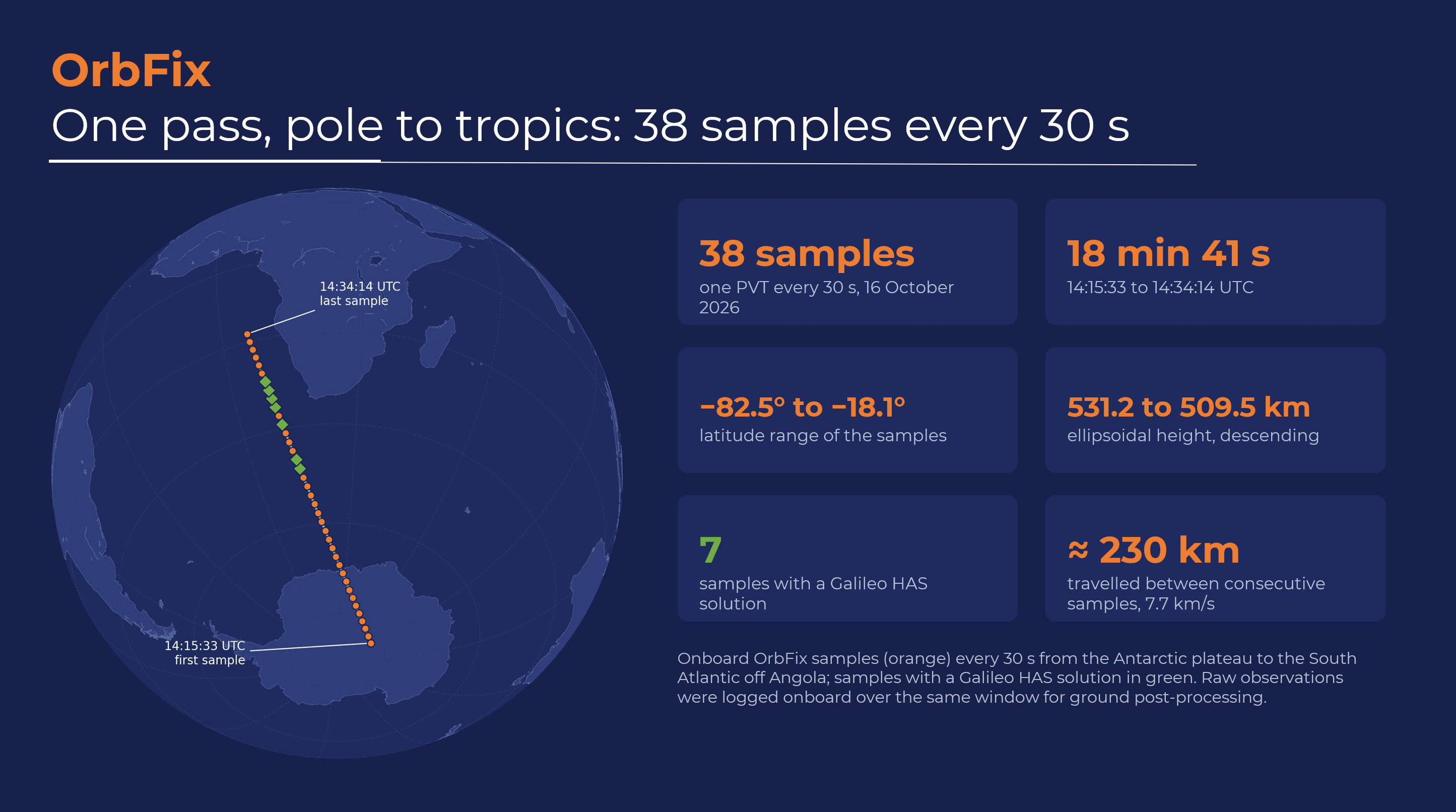
Antarctica and South Atlantic Pass Over results
The Galileo HAS solution exhibited a clear convergence behaviour following the reception of correction messages. Analysis of the raw data revealed periodic reinitialisation of the PPP navigation filter approximately every 210 seconds, consistent with the satellite’s rotation rate of roughly 3°/s. As the spacecraft rotated, the onboard GNSS antenna periodically pointed towards Earth, interrupting the GNSS satellite signals tracking and limiting continuous convergence.
After removing the outliers, the onboard Galileo HAS positioning achieved a three-dimensional accuracy of 0.65 m, compared with 1.85 m for standalone GNSS positioning, representing an improvement of approximately 65%. Post-processing of the raw data using the same navigation filter resulted in a mean three-dimensional error of 0.34 m after 154 seconds of convergence, demonstrating the level of performance achievable under continuous GNSS tracking conditions.
Although the 20-minute experiment did not allow full PPP convergence, the Galileo HAS solution remained stable throughout the test. The main limiting factor was the periodic loss of GNSS tracking caused by the spacecraft's rotation, which repeatedly interrupted the convergence process.
“The quick convergence of Galileo HAS positioning to sub-meter errors confirms the applicability of Galileo HAS corrections in LEO conditions and demonstrates the potential of operational high-accuracy GNSS services for future autonomous spacecraft”, says Dr. Alexandru Pandele, Chief Commercial Officer at RISE.
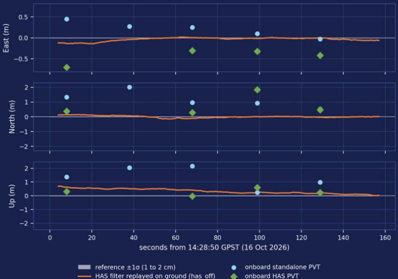
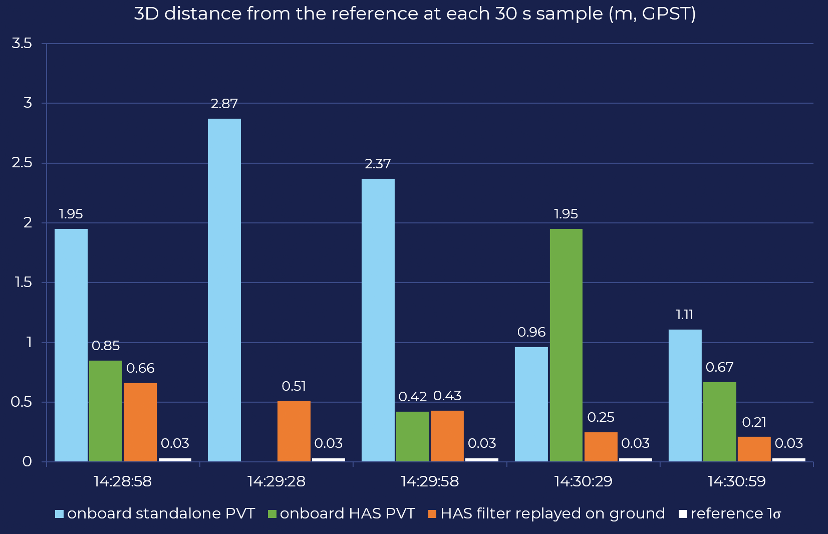
Galileo HAS in space data
The demonstration confirmed OrbFIX’s ability to deliver sub-metre navigation performance at orbital altitudes above 500 km. Future OrbFIX experiments will aim to demonstrate decimetre-level accuracy in space. Overall, the results provide strong evidence that Galileo HAS can support next-generation space applications requiring enhanced onboard navigation accuracy.
Impact
The successful demonstration provides one of the first practical validations of an operational Galileo service in a space environment and highlights the potential of extending Galileo HAS beyond terrestrial use cases.
As spacecraft become increasingly autonomous and large satellite constellations continue to expand, access to free, globally available high-accuracy corrections directly from the Galileo system has the potential to reduce operational complexity while significantly improving onboard navigation performance.
Spaceborne applications expected to benefit from Galileo HAS include:
• Precise Orbit Determination (POD)
• Formation flying (FF)
• Rendezvous (RVX) and close proximity operations (CPO)
• Space Situational Awareness and Space Surveillance & Tracking (SSA/SST)
• Constellation-wide precise timing and synchronisation
About Galileo
Galileo, the EU´s Global Navigation Satellite System (GNSS), provides improved navigation, positioning and timing information. More than 4.5 billion users are already benefitting from Galileo.
The Galileo Programme is owned by the EU. The European Commission, as the Programme Manager, oversees the implementation of all activities. EUSPA is responsible for the operational management of the services, ensuring their availability, continuity and performance, and for the procurement of launch services required for the deployment and replenishment of the constellation. Galileo's system design and system evolution are entrusted by EUSPA to ESA.
Media note: This feature can be republished without charge provided the European Union Agency for the Space Programme (EUSPA) is acknowledged as the source at the top or the bottom of the story. You must request permission before you use any of the photographs on the site. If you republish, we would be grateful if you could link back to the EUSPA website (https://www.euspa.europa.eu)