What is SAR/Galileo
The Search And Rescue service of Galileo, referred as “SAR/Galileo” is Europe’s contribution to the global life-saving endeavour of the Cospas-Sarsat (C/S) Programme. It integrates the MEOSAR (Medium Earth Orbit Search And Rescue) capacity of Galileo in the existing C/S system, delivering a major boost in terms of speed and accuracy detecting distress beacons signals.
The SAR/Galileo service, launched in 2016 contributes with an unprecedented speed and accuracy to live-saving efforts by relaying distress signals of dedicated beacons to the relevant SAR crews, using dedicated payloads aboard Galileo satellites and the ground segment strategically deployed across Europe and overseas territories.
The SAR/Galileo Return Link Service (RLS) is operational since early 2020. The RLS provides an automatic acknowledgement message informing the beacon user their request for help has been received and their position computed.
The SAR/Galileo Service is operational in Full Operational Capability since October 2024 reaffirming Europe’s commitments to the safety and security of SAR operations around the globe.
For more information about the Minimum Performance Levels, refer to the SAR/Galileo Service Definition Document.
How the SAR/Galileo service works
Europe is the most important contributor to the Cospas-Sarsat MEOSAR programme in terms of ground segment and space segment assets thanks to SAR/Galileo Service. It provides the following two functionalities:
The SAR/Galileo Forward Link: relays the Cospas-Sarsat 406MHz distress signals to the ground segment;
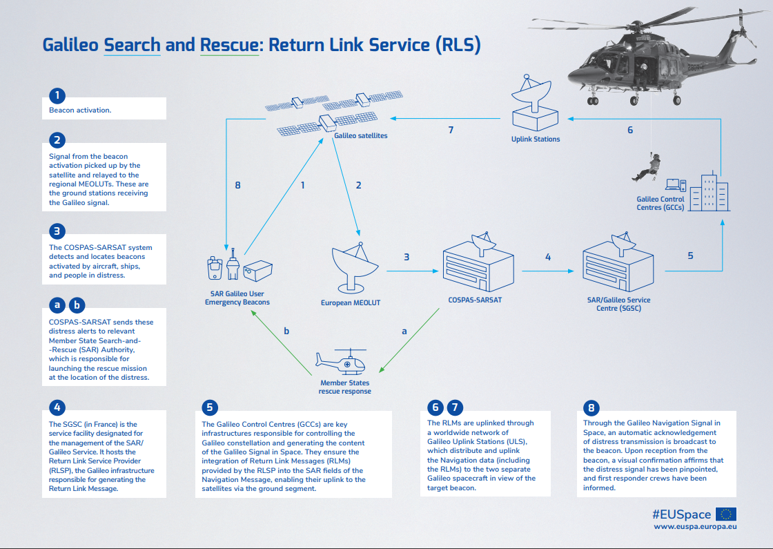
The SAR/Galileo Forward Link Service is seamlessly integrated into the Cospas-Sarsat system. The SAR transponders aboard Galileo satellites pick up signals emitted anywhere in the world by distress beacons in the 406 – 406.1MHz band and relay them in the L-band on 1544.1MHz without any on-board processing, data storage or demodulation, to every MEOLUT in view. The MEOLUTs process these downlink signals, independently compute the location of the user in distress, and relay it to the rescue station nearest to the incident via dedicated Cospas-Sarsat Mission Control Centres.
The SAR/Galileo’s Return Link
The SAR Galileo Return Link Service is a unique feature providing RLS-enabled beacons with an automatic acknowledgement, confirming that their distress signal has been received and their position computed.
With the significant improvements enabled by these functionalities of SAR/Galileo , more lives can be saved. Read more here.
How can you benefit from SAR/Galileo? Get your own beacon!There are 3 major categories of beacons: ELT’s (Emergency Locator Transmitters) are beacons designed for use aboard aircrafts. They are linked to the Aircraft’s registration. EPIRB’s (Emergency Position-Indicating Radio Beacons) are designed for use aboard vessel to which they are registered. PLB’s (Personal Locator Beacons) are designed to be carried by an individual. They are registered to a person, and are the most versatile type of beacon, as they can support all kind of outdoor activities, like nautical (sailing, kayaking, ..), trekking, hiking, hobby flying, etc ... EUSPA contributed to the adoption of the RLS functionality by beacon manufacturers. A complete list of these devices, now widely available on the market is available on the GSC webpage. What is Cospas-Sarsat?Cospas-Sarsat is a non-profit satellite-based search and rescue distress alert detection and information distribution system. It provides accurate, timely, and reliable distress alert and location data to SAR authorities, increasing the survival chances of people in distress by reducing the time it takes to locate them and relay this information to responders. For more details on Cospas-Sarsat, please refer to the Cospas-Sarsat site. |